The Evolution of the Mojave Cutoff
Before the asphalt of Route 66 was laid across the desert in the late 1920s, early motorists followed primitive dirt tracks surveyed along historic Indigenous footpaths and 19th-century wagon trails. The establishment of the National Old Trails Highway in 1912 marked the first coordinated effort to create a ocean-to-ocean highway system across the United States.
In eastern San Bernardino County, this alignment mirrored the transcontinental railway tracks laid down by the Atlantic and Pacific Railroad (later the Santa Fe Railway). Water stops established every few miles for steam locomotives quickly blossomed into small desert communities. When Route 66 was officially designated in 1926, these isolated outposts transformed overnight into crucial pit stops for gas, mechanical repairs, home-cooked meals, and respite from the scorching desert heat.
Goffs: Crossroads of Railroad and Highway Heritage
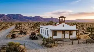
Beginning your journey near the eastern boundary of San Bernardino County, the small settlement of Goffs sits at a high-desert elevation of over 2,500 feet. Originally established as a railroad siding in 1883, Goffs became an essential junction point where miners, ranchers, and early transcontinental drivers crossed paths.
The undisputed historic anchor of the town is the Goffs Schoolhouse. Built in 1914, this Mission Revival-style wooden building served the community’s children for decades before being carefully restored by the Mojave Desert Heritage and Cultural Association. Today, the surrounding 75-acre site functions as an open-air museum housing vintage mining machinery, historical artifacts, and one of the most comprehensive archives of desert history in Southern California.
Standing on the grounds of the schoolhouse, visitors can trace the physical evolution of desert travel—from heavy ore wagons to mid-century automobiles—against a backdrop of sweeping desert hills and Joshua tree stands.
Essex and the Mirage of Desert Springs
Heading southwest along the National Trails Highway brings you to Essex. During the height of Route 66 travel in the 1930s and 1940s, Essex was famous among motorists for one priceless commodity: reliable fresh water.
In an era when early automobile engines frequently overheated while crossing the desert, Essex provided crucial wells funded by the local community. The town boasted garages, general stores, and cozy roadside cabins. Today, while many of the original commercial buildings stand in ruin or have succumbed to the elements, Essex retains a quiet, contemplative atmosphere that evokes the solitude of early cross-country motoring.
Essential Route 66 Desert Driving Checklist:
- Fuel Up Early: Gas stations are non-existent across long stretches between Needles, Barstow, and Twentynine Palms. Start with a full tank.
- Carry Emergency Supplies: Pack extra drinking water (at least one gallon per person per day), non-perishable food, and a fully charged power bank.
- Check Road Conditions: Desert flash floods can periodically wash out low-lying bridge crossings along old Highway 66.
- Respect Private Property: Many roadside structures along the cutoff are historic ruins on private land; view and photograph from public rights-of-way.
Amboy: The Heartbeat of the Mojave Road
Continuing deeper into the trough of the Mojave Desert, the horizon opens up to reveal one of the most iconic sights on all of Route 66: the giant boomerang-shaped neon sign of Roy’s Motel & Café in Amboy.
Founded in 1938 by Roy Crowl and later expanded alongside his partner Herman “Buster” Burris, Roy’s was built to be a self-contained oasis. At its peak, the complex operated 24 hours a day, employing dozens of local residents to serve the endless stream of travelers moving between Chicago and Los Angeles. Its distinctive mid-century modern reception office, built in 1959 with an exaggerated googie-style roofline, remains a masterpiece of American roadside architecture.
Though the bypass of Interstate 40 in 1973 turned Amboy into a near ghost town virtually overnight, ongoing preservation efforts have breathed new life into the landmark. Today, visitors can stop by to purchase souvenirs, grab cold drinks, and take photos beneath the restored neon sign that still stands as a beacon across the desert basin.
Volcanic Geology at Amboy Crater
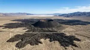
Just a short drive west of Roy’s Café lies a stark contrast to the historic man-made landmarks: the dramatic volcanic topography of Amboy Crater. Designated as a National Natural Landmark, this 250-foot-high extinct cinder cone formed roughly 10,000 years ago, spewing vast basaltic lava fields across the desert floor.
A 3-mile round-trip hiking trail leads visitors from a shaded staging area across the craggy black lava beds directly into the breach of the crater’s western wall. Climbing to the crater rim yields panoramic 360-degree views of the Bullion Mountains, the dry expanse of Amboy Sink, and the faint asphalt ribbon of historic Route 66 stretching toward the horizon.
Preserving the Silence of the Mother Road
Driving the Mojave Cutoff is more than a scenic detour—it is an immersive journey through time. Away from the hum of modern freeway traffic, the expanse of San Bernardino County offers a rare look at the vastness that challenged and captivated early 20th-century explorers.
As preservation groups, historians, and local stewards work to protect these historic structures and natural vistas, the National Trails Highway remains an unmissable corridor for anyone seeking the authentic spirit of America’s most famous highway.